Overview
A flood is an overflow of an expanse of water that submerges land.The EU Floods
directive defines a flood as a temporary covering by water of land not normally
covered by water.In the sense of "flowing water", the word may also be applied to
the inflow of the tide. Flooding may result from the volume of water within a body
of water, such as a river or lake, which overflows or breaks levees, with the result
that some of the water escapes its usual boundaries.While the size of a lake or
other body of water will vary with seasonal changes in precipitation and snow melt,
it is not a significant flood unless the water covers land used by man like a village,
city or other inhabited area, roads, expanses of farmland, etc.
River and coastal flooding are the most frequently occurring natural disaster and
are increasing in occurrence more rapidly than any other disaster. Urbanization
and deforestation reduce the capability of the earth to hold excess water. As asphalt-
and concrete-covered surfaces expand and open spaces disappear at the edges of metropolitan
areas, it takes less rain to flood communities as water running over the pavement
collects quickly and easily disrupts storm drain systems. Those areas which are
most at risk for floods include low-lying areas, coastal regions, and communities
on rivers downstream from dams. Flood waters are extremely dangerous; a mere six
inches of swiftly moving water can knock people off their feet. In some places flooding
is caused by excessive monsoons, while in others flooding is caused downstream from
dams when reservoirs, which normally help to prevent downstream areas of rivers
from flooding, are opened due to unusually high levels of rain to prevent the reservoir
from overflowing the dam. Dam breaks are also a cause of catastrophic flooding.
West Bengal has 37,660 sq. km flood prone area spread over 111 blocks where the
total geographical area of the state is 88,752 sq. km. An analysis of the statistics
of flood that occurred during last 41 years (from 1960 - 2000) shows that only on
5 occasions the state has not faced any severe flood. The total devastated area
crossed 20,000 sq. km in 4 different years and the flood of medium magnitude i.e.
between 2,000 to 10,000 sq. km. occurred on 10 occasions.
The Flood Problem
The flood problems of the state are of different nature at different regions. The
rivers Teesta, Torsa, Jaldhaka, Raidak-I, Raidak-II etc. flowing through the districts
of Jalpaiguri and Cooch Behar originate in the neighbouring country of Bhutan and
the state of Sikkim and flows down to Bangladesh, another neighbouring country to
meet the Bramhaputra at different locations. The rivers of the districts of Uttar
Dinajpur and Dakshin Dinajpur originating at Bangladesh passes through these districts
and then joins the Ganga-Padma at downstream of Farakka in Bangladesh. Both the
places of origin and also the outfall of most of these rivers are in Bangladesh.
The district of Malda through which the river Ganga flows receives its flood water
from about 11 (eleven) States and is battered by the run-off flow generated from
these vast areas. Ultimately the river flows down the Farakka Barrage to Bangladesh.
Another portion of the Malda district receives floodwaters of the Mahananda, which
again originates in the hills of the neighbouring country of Nepal and has some
catchment area in the neighbouring state of Bihar and then passes through the district
to join the Ganga-Padma at downstream of Farakka Barrage in Bangladesh.Major contributing
factors to flood in North Bengal regions are the run-off because of heavy local
rainfall, discharge of upper basin areas and also outfall condition in the neighbouring
countries. The Mahananda and most of the rivers of Uttar and Dakshin Dinajpur districts
get stagnated when the Ganga upstream and downstream of Farakka Barrage rules high
thereby not allowing drainage of flood discharge during that period.
Analysis of Area Flooded against Years of Occurrence
|
Flood affected area (in sq. km)
|
Years during which the flood occurred
|
Total No. of years
|
|
Below 500
|
1985, 89, 92, 94 & 97
|
5
|
|
Between 500 - 2000
|
1962, 63, 64, 65, 66, 72, 75 & 96
|
8
|
|
2000 - 5000
|
1960, 61, 67, 69, 70, 74, 76, 80, 81 & 82
|
10
|
|
5000 - 10000
|
1973, 77, 93, 95 & 98
|
5
|
|
10000 - 15000
|
1968, 79, 83, 90 & 99
|
5
|
|
15000 – 20000
|
1971, 86, 87 & 88
|
4
|
|
Above 20000
|
1978, 84, 91 & 2000
|
4
|
Types of Flood
It is a temporary inundation of large regions as a result of an increase in reservoir,
or of rivers flooding their banks because of heavy rains, high winds, cyclones storm
surge along coast, tsunami, melting snow or dam bursts.
- Flash Floods
It is defined as floods which occurs within six hours of the beginning of heavy
rainfall, and are usually associated with cloud bursts, storms and cyclones requiring
rapid localized warning and immediate response if damage is to be mitigated. In
case of flash floods, warning for timely evacuation may not always be possible.
- River Floods
Such floods are caused by precipitation over large catchment’s areas. These floods
normally build up slowly or seasonally and may continue for days or weeks as compared
to flash floods.
- Coastal Floods
Some floods are associated with the cyclonic activities like Hurricanes, tropical
cyclone etc. Catastrophic flooding is often aggravated by wind-induced strom surges
along the coast.
River System In West Bengal
The Ganga-Padma river artery divides the state in two parts, north and south. Being
a part of Ganga-Bhrammhaputra-Meghna basin, North Bengal is extremely flood prone.
The rivers Teesta, Torsa, Jaldhaka, Raidak-I, Raidak-II and their numerous tributaries
belonging to the Brammhaputra basin and flowing through a part of Darjeeling, Jalpaiguri
and Coochbehar originate in the Himalayas of Sikkim and Bhutan and flows south-east
to Bangladesh. A part of Darjeeling and the districts of Uttar Dinajpur, Dakshin
Dinajpur and Malda are drained through the rivers of Mahananda, Dauk, Tangon, Nagar,
Atreyee, Punarbhaba and their tributaries. These are part of Ganga basin. Except
the Mahananda, all other rivers originate in the plain of West Bengal and Bangladesh
and join the Ganga-Padma at downstream of Farakka in Bangladesh. The Mahananda emerges
from the Nepal Himalayas. Malda through which the river Ganga Flows receives its
flood water from about eleven states and batters by the run-off flow generated from
these vast areas. In central and southern part of this state, there are certain
distinctive features of drainage condition which gives rise to flood situation.
Basin-wise there are a number of rivers on the right bank of the Bhagirathi-Hoogly.
These are Pagla-Bansloi, the Dwarka-Bramhani, the Mayurakshi-Babla-Uttarasan, the
Bakreswar-Kuye and also the Ajoy. They emerge from the Jharkhand Plateau an flow
southeast to meet Bhagirathi-Hoogly. These rivers drain an area of 17,684 km. spread
over the State Jharkhand and Birbhum, western part of Murshidabad and Burdwan. Originating
from Ganga-Padma, the Bhairab-Jalangi-Sealmari system of rivers drain the eastern
part of Murshidabad and meet the Bhagirathi at Swarupnagar in Nadia. Nadia is drained
partly by Jalangi and partly by the Churni which is a part of Mathabhanga-Churni-Ichamati
system, taking off from Ganga-Padma flowing southwest, to meet Bhagirathi on the
east bank at Ranaghat. The other part viz. the Ichamati flows east through Bangladesh
enters the district of Uttar 24 Paraganas, flows in the south direction to fall
into the tidal creek of the Raimangal. Part of Howrah and Uttar and Dakshin 24 Paraganas
are drained mainly by the Hoogly and its tidal creeks and other internal drainage
canals. Burdwan, Howrah and Hoogly districts are mainly drained by Damodar and Bhagirathi-Hoogly
Rivers. In the Damodar-Barakar basin system, the rivers originate at Chotanagpur
plateau and flow down the plains of West Bengal to meet Bhagirathi. The Ajoy forms
the border between Birbhum and Burdwan. Purulia and Bankura are drained by the rivers
of Kangsabati, Kumari, Shilabati, Keleghai, Dwarakeswar and their tributaries. The
Keleghai also drains Paschim Medinipur and a part of Purba Medinipur. These rivers
originate from the western highland of the state and flow in southeast direction
to form the tidal rivers of the Rupnarayan and the Haldi to meet the Hoogly on the
west bank. The Rupnarayan forms the boundary between Hoogly and Purba Medinipur.
A part of Purba Medinipur is drained by the river Subarnarekha originating from
the Jharkhand Plateau and flowing in southwest direction to meet the Bay of Bengal
in Orissa.
Causes of Flood
- Excessive rainfall in river catchments or concentration of runoff from the tributaries
and river carrying flows in excess of their capacities.
- Backing of water in tributaries at their confluence with the main river.
- Synchronization of flood peaks of the main rivers and tributaries.
- Landslides causing obstruction to flow and change in the river course.
- Poor natural drainage.
- Cyclone and very intense rainfall.
- Intense rainfall when river is flowing full.
The floods of West Bengal have special characteristics. Heavy rainfall at origin
or catchment’s areas of main flooding rivers of this state cause flood, but these
areas are mainly lying outside this state. The West Bengal is flooded by water from
adjoining states or countries.
Major contributing factors to flood in Northern regions are the run-off because
of heavy local rainfall, discharge of upper basin areas and also out fall condition
in the neighbouring countries. The Mahananda and most of the rivers of Uttar and
Dakshin Dinajpur districts get stagnated when the Ganga upstream and downstream
of Farakka Barrage rules high there by not allowing draining of flood discharge
during that period. Flooding Malda is caused by the rivers Fulhar-Mahananda-and
Ganga. The Ganga, forming the southern boundary of the district, brings flood water
from eleven states and Nepal. The Fulhar meets the Ganga upstream of Farakka.
The rivers of rivers of Bhagirathi-Hoogly basin generate flood because of high rainfall
and limited carrying capacity of the river Bhagirathi from Jangipur in Murshidabad
to Kalna in Bardwan. In this reach the Bhagirathi has discharge carrying capacity
of maximum 1.3 lac. Cusec. But all these rivers if receive rainfall simultaneously
in their catchment areas can generate run-off volume of any amount between 4-6 lac.
Cusec. In this vast tract of land there is only the Massanjore dam to interfere
with the natural flow of flood water.
The basic reason of flood in this zone is the shape of the catchment area, its steep
slope from a high level plateau area sloping sharply down to aflat terrain near
the outfall and also adverse outfall condition because of its limited intake capacity.
This feature is again adversely affected by the tidal condition as is generally
noticed in the month of September, when the Hoogly is in high tide condition. Delay
in drainage causes more accumulation resulting in spread of flood in the upstream
of the river system in the west and beyond Berhampur. Generally part of Murshidabad
and Nadia suffer from flood because of three reasons –
- High intensity rainfall in the basin area of Bhairabi-Jalangi-Sealmari itself,
- Inflow of flood water from Ganga-Padma at its high spate and
- Drainage congestion at its outfall because of the high stage of Bhagirathi.
Traditionally, Damodar basin was known to be a curse. The basin of river Damodar
has a very special shape and this influences its flood pattern. The river has about
70% of its basin just upstream of Durgapur town. This upper catchments of Jharkhand
plateau, above Durgapur, generates heavy run-off during high rainfall and is carried
to Durgapur in a short time. From here, this discharge travels through the river,
bifurcating at Beguahana. One branch, the lower Damodar with very small capacity,
reaches the Hoogly on the west bank. The major discharge passes through the Mundeswari
to meet the Rupnarayan. Any major discharge along the downstream of Durgapur Barrage
may cause flood depending upon the outfall condition of the Mundeswari at Harinkhola.
In Kangsabati river system, the Kangsabati Dam has a limited flood storage capacity
which is very nominal. Any major spillway discharge from Kangsabati Dam may cause
flood at lower areas downstream of Medinipur town depending on tide and downstream
rainfall.
Occurrence of Flood
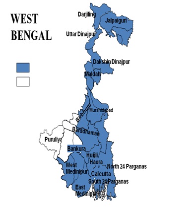 Blue Areas depict Flood Affected Area
|
Flood
|
North Bengal
|
South Bengal
|
|
Districts Affected by Flood
|
Cooch Behar, Jalpaiguri, Uttar Dinajpur, Dakshin Dinajpur, Malda;
|
Nadia, Howrah, Murshidabad, North 24 Parganas, South 24 Parganas, Hooghly, Burdwan,
Birbhum, Paschim Medinipur, Purba Medinipur
|
|
Relatively scare Districts affected by Flood
|
Darjeeling
|
Puruliya & Bankura
|
Flood Among natural hazards, occurrence of flood ranks first in West Bengal which
has become annual festival in the State. Almost all the districts are affected by
flood from July to October. But flood is relatively scarce in Darjeeling in North
Bengal and Bankura & Purulia in South Bengal. The detail is depicted in the following
matrix. According to the Irrigation Department, 37.6 lakhs Ha of West Bengal (42.4%
of the total geographical area and 69% of its net cropped area) has been identified
as flood prone area; of this 29.8 lakh Ha ( i.e., 58% of the flood prone area) is
Protected Area. Strong monsoon, rivers and floods are an integral part of Bengal’s
characteristic ecology that shaped its civilization and culture and at the same
time, cause of flood hazard and disasters for the society as a whole.
Followings are the records of large FLOODS in West Bengal
|
Period
|
Description
|
|
1978
|
Major Flood
|
|
1986
|
Flooding due to heavy rains in some areas of Kolkata, Hooghly, Howrah, Parganas
and Midnapore
|
|
1988
|
Monsoonal rains caused flooding in areas of Balurghat and Dinajpur lying under the
purview of the Ganges and Churani rivers
|
|
1991
|
Flash floods caused damage 35,000 houses
|
|
1995
|
Flooding triggered by heavy rains caused erosion, severe agricultural damage and
outbreak of diseases
|
|
1998
|
Monsoon rains caused flooding of the Ganges River
|
|
1999
|
Tropical cyclones caused destruction of an estimated number of 1500 villages. Floods
due to brief torrential rains affected areas of Kolkata, Burdwan and Birbhum
|
|
2000
|
Besides flash floods triggered by incessant torrential rains, disaster is also accredited
to the opening of sluice gates of dams. The fatalities counted to the tune of 1262,
besides affecting millions of people.
|
|
2002
|
Flooding in Jalpaiguri, Cooch Behar and Jalpaiguri in north Bengal due to monsoonal
rains. Flash floods swamped ten villages, causing four deaths and 11,000 displacements
|
|
2003
|
Monsoonal rains caused floods affecting the regions of Darjeeling, Jalpaiguri, Malda
and Murshidabad
|
|
2004
|
Heavy monsoonal rains affected several districts
|
|
2005
|
Heavy rains caused floods in many areas. About 3000 coastal villages were inundated
and 60,000 huts and many roads washed away.
|
|
2005
|
Heavy rains caused floods in many areas. About 3000 coastal villages were inundated
and 60,000 huts and many roads washed away. Heavy monsoon rains triggered flash
floods and landslides
|
|
2006
|
The regions of Birbhum, Burdwan and Murshidabad were affected mainly from continuous
monsoonal downpour Monsoonal rains and tropical cyclone-driven storms in the Bay
of Bengal hit India and Bangladesh. West Bengal recorded 50 deaths, 300 were injured
and 30,000 mud houses destroyed. Heavy rains left large parts of Kolkata city under
water; subsequently 2000 people were evacuated from the city.
|
|
2007
|
Heavy rain from tropical depression in the Bay of Bengal caused flooding leading
to 51 deaths, and affecting 3.2 million people.
|
|
2013
|
Heavy rainfall & water release from various dams by DVC led to widespread flooding
in the districts of Paschim & Purba Medinipur, Howrah, Hooghly, Bardhaman and Bankura
Causing 17 deaths, 8790 villages affected, and affecting 2.1 miillion people
|
Elements At Risk
Anything in the flood plains will get inundated. building built of earth, weak foundations,
and soluble materials will collapse endangering humans and their property. Basements
of buildings are under risk. Utilities such as sewerage, water supply, communication
lines, and power are put at risk. Food stock in the godowns, agricultural fields,
livestock, vehicles, machinery and equipments mounted on the ground, fishing boats
are also put at risk.